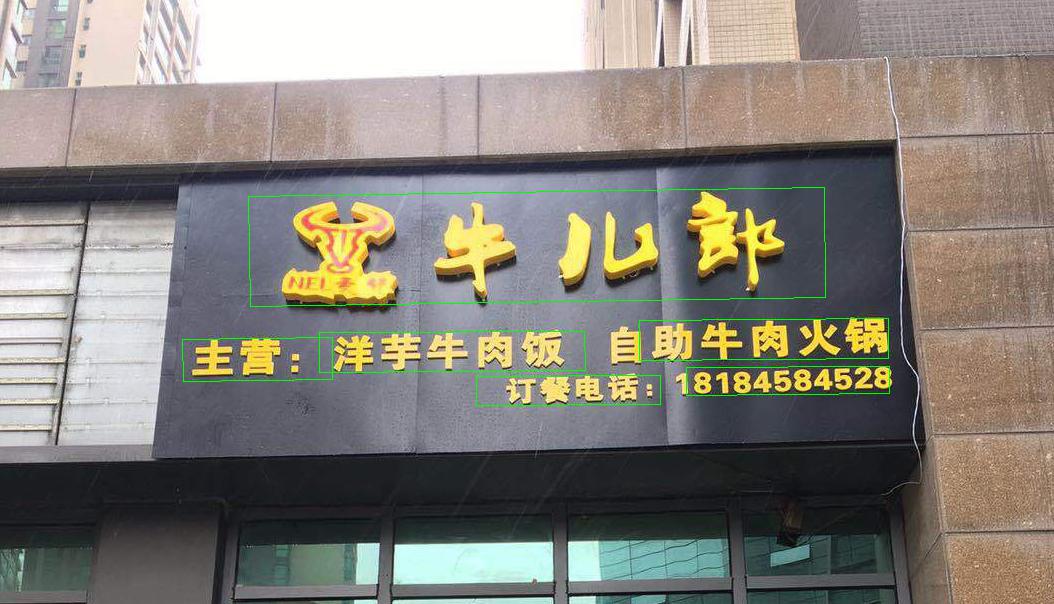
Results
Results
dataset.py
dataset.py
Import
Import
from shapely.geometry import Polygon from abc import ABC, abstractmethod from torch.utils.data import Dataset from PIL import Image from torchvision.transforms import transforms import torch import os import numpy as np import math import cv2
CustomDataset
CustomDataset
class CustomDataset(Dataset): def __init__(self, img_path, gt_path, scale=0.25, length=512): super(CustomDataset, self).__init__() self.img_files = [] for img_file in sorted(os.listdir(img_path)): if img_file.endswith(".jpg") or img_file.endswith(".png"): self.img_files.append(os.path.join(img_path, img_file)) self.gt_files = [] for gt_file in sorted(os.listdir(gt_path)): if gt_file.endswith(".txt"): self.gt_files.append(os.path.join(gt_path, gt_file)) self.scale = scale self.length = length def __getitem__(self, index): with open(self.gt_files[index], 'r', encoding="utf-8") as f: lines = f.readlines() vertices, labels = extract_vertices(lines) img = Image.open(self.img_files[index]) img, vertices = adjust_height(img, vertices) img, vertices = rotate_img(img, vertices) img, vertices = crop_img(img, vertices, labels, self.length) transform = transforms.Compose([transforms.ColorJitter(0.5, 0.5, 0.5, 0.25), transforms.ToTensor(), transforms.Normalize(mean=(0.5, 0.5, 0.5), std=(0.5, 0.5, 0.5))]) score_map, geo_map, ignored_map = get_score_geo(img, vertices, labels, self.scale, self.length) return transform(img), score_map, geo_map, ignored_map def __len__(self): return len(self.img_files)
extract_vertices
extract_vertices
def extract_vertices(lines): '''extract vertices info from txt lines Input: lines : list of string info Output: vertices: vertices of text regions <numpy.ndarray, (n,8)> labels : 1->valid, 0->ignore, <numpy.ndarray, (n,)> ''' labels = [] vertices = [] for line in lines: vertices.append(list(map(int, line.rstrip('\n').lstrip('\ufeff').split(',')[:8]))) label = 0 if '###' in line else 1 labels.append(label) return np.array(vertices), np.array(labels)
adjust_height
adjust_height
def adjust_height(img, vertices, ratio=0.2): '''adjust height of image to aug data Input: img : PIL Image vertices : vertices of text regions <numpy.ndarray, (n,8)> ratio : height changes in [0.8, 1.2] Output: img : adjusted PIL Image new_vertices: adjusted vertices ''' ratio_h = 1 + ratio * (np.random.rand() * 2 - 1) old_h = img.height new_h = int(np.around(old_h * ratio_h)) img = img.resize((img.width, new_h), Image.BILINEAR) # PIL api (caution, widthxheight) new_vertices = vertices.copy() if vertices.size > 0: new_vertices[:, [1, 3, 5, 7]] = vertices[:, [1, 3, 5, 7]] * (new_h / old_h) return img, new_vertices
rotate_img
rotate_img
def rotate_img(img, vertices, angle_range=10): '''rotate image [-10, 10] degree to aug data Input: img : PIL Image vertices : vertices of text regions <numpy.ndarray, (n,8)> angle_range : rotate range Output: img : rotated PIL Image new_vertices: rotated vertices ''' center_x = (img.width - 1) / 2 center_y = (img.height - 1) / 2 angle = angle_range * (np.random.rand() * 2 - 1) # from -10 to 10 img = img.rotate(angle, Image.BILINEAR) # PIL api new_vertices = np.zeros(vertices.shape) for i, vertice in enumerate(vertices): new_vertices[i, :] = rotate_vertices(vertice, -angle / 180 * math.pi, np.array([[center_x], [center_y]])) return img, new_vertices
rotate_vertices
rotate_vertices
def rotate_vertices(vertices, theta, anchor=None): '''rotate vertices around anchor Input: vertices: vertices of text region <numpy.ndarray, (8,)> theta : angle in radian measure anchor : fixed position during rotation Output: rotated vertices <numpy.ndarray, (8,)> ''' v = vertices.reshape((4, 2)).T if anchor is None: anchor = v[:, :1] rotate_mat = get_rotate_mat(theta) res = np.dot(rotate_mat, v - anchor) return (res + anchor).T.reshape(-1)
get_rotate_mat
get_rotate_mat
def get_rotate_mat(theta): '''positive theta value means rotate clockwise''' return np.array([[math.cos(theta), -math.sin(theta)], [math.sin(theta), math.cos(theta)]])
crop_img
crop_img
def crop_img(img, vertices, labels, length): '''crop img patches to obtain batch and augment Input: img : PIL Image vertices : vertices of text regions <numpy.ndarray, (n,8)> labels : 1->valid, 0->ignore, <numpy.ndarray, (n,)> length : length of cropped image region Output: region : cropped image region new_vertices: new vertices in cropped region ''' h, w = img.height, img.width # confirm the shortest side of image >= length if h >= w and w < length: img = img.resize((length, int(h * length / w)), Image.BILINEAR) elif h < w and h < length: img = img.resize((int(w * length / h), length), Image.BILINEAR) ratio_w = img.width / w ratio_h = img.height / h assert(ratio_w >= 1 and ratio_h >= 1) new_vertices = np.zeros(vertices.shape) if vertices.size > 0: new_vertices[:, [0, 2, 4, 6]] = vertices[:, [0, 2, 4, 6]] * ratio_w new_vertices[:, [1, 3, 5, 7]] = vertices[:, [1, 3, 5, 7]] * ratio_h # find random position remain_h = img.height - length remain_w = img.width - length flag = True cnt = 0 while flag and cnt < 1000: cnt += 1 start_w = int(np.random.rand() * remain_w) start_h = int(np.random.rand() * remain_h) flag = is_cross_text([start_w, start_h], length, new_vertices[labels == 1, :]) box = (start_w, start_h, start_w + length, start_h + length) region = img.crop(box) if new_vertices.size == 0: return region, new_vertices new_vertices[:, [0, 2, 4, 6]] -= start_w new_vertices[:, [1, 3, 5, 7]] -= start_h return region, new_vertices
is_cross_text
is_cross_text
def is_cross_text(start_loc, length, vertices): '''check if the crop image crosses text regions Input: start_loc: left-top position length : length of crop image vertices : vertices of text regions <numpy.ndarray, (n,8)> Output: True if crop image crosses text region ''' if vertices.size == 0: return False start_w, start_h = start_loc a = np.array([start_w, start_h, start_w + length, start_h, start_w + length, start_h + length, start_w, start_h + length]).reshape((4, 2)) p1 = Polygon(a).convex_hull epsilon = 1e-6 for vertice in vertices: p2 = Polygon(vertice.reshape((4, 2))).convex_hull inter = p1.intersection(p2).area if 0.01 <= inter / (p2.area + epsilon) <= 0.99: return True return False
get_score_geo
get_score_geo
def get_score_geo(img, vertices, labels, scale, length): '''generate score gt and geometry gt Input: img : PIL Image vertices: vertices of text regions <numpy.ndarray, (n,8)> labels : 1->valid, 0->ignore, <numpy.ndarray, (n,)> scale : feature map / image length : image length Output: score gt, geo gt, ignored ''' score_map = np.zeros((int(img.height * scale), int(img.width * scale), 1), np.float32) geo_map = np.zeros((int(img.height * scale), int(img.width * scale), 5), np.float32) ignored_map = np.zeros((int(img.height * scale), int(img.width * scale), 1), np.float32) index = np.arange(0, length, int(1 / scale)) index_x, index_y = np.meshgrid(index, index) ignored_polys = [] polys = [] for i, vertice in enumerate(vertices): if labels[i] == 0: ignored_polys.append(np.around(scale * vertice.reshape((4, 2))).astype(np.int32)) continue poly = np.around(scale * shrink_poly(vertice).reshape((4, 2))).astype(np.int32) # scaled & shrinked polys.append(poly) temp_mask = np.zeros(score_map.shape[:-1], np.float32) cv2.fillPoly(temp_mask, [poly], 1) theta = find_min_rect_angle(vertice) rotate_mat = get_rotate_mat(theta) rotated_vertices = rotate_vertices(vertice, theta) x_min, x_max, y_min, y_max = get_boundary(rotated_vertices) rotated_x, rotated_y = rotate_all_pixels(rotate_mat, vertice[0], vertice[1], length) # given p in Polygon(vertice), top_distance = p - Pr_{top_L}(p) = r(p)_y - r(Pr_{top_L}(p))_y = r(p)_y - ymin # where r is the rotation anchored at the top-left corner # and p in Polygon(vertice) only if r(p)_y - ymin >= 0 # d1 = distance from top to point (j, i) # the gt is top, bottom, left, right (上, 下, 左, 右) d1 = rotated_y - y_min d1[d1 < 0] = 0 d2 = y_max - rotated_y d2[d2 < 0] = 0 d3 = rotated_x - x_min d3[d3 < 0] = 0 d4 = x_max - rotated_x d4[d4 < 0] = 0 geo_map[:, :, 0] += d1[index_y, index_x] * temp_mask geo_map[:, :, 1] += d2[index_y, index_x] * temp_mask geo_map[:, :, 2] += d3[index_y, index_x] * temp_mask geo_map[:, :, 3] += d4[index_y, index_x] * temp_mask geo_map[:, :, 4] += theta * temp_mask cv2.fillPoly(ignored_map, ignored_polys, 1) cv2.fillPoly(score_map, polys, 1) return torch.Tensor(score_map).permute(2, 0, 1), torch.Tensor(geo_map).permute(2, 0, 1), torch.Tensor(ignored_map).permute(2, 0, 1)
shrink_poly
shrink_poly
1def shrink_poly(vertices, coef=0.3):
2    '''shrink the text region
3    Input:
4            vertices: vertices of text region <numpy.ndarray, (8,)>
5            coef    : shrink ratio in paper
6    Output:
7            v       : vertices of shrinked text region <numpy.ndarray, (8,)>
8    '''
9    x1, y1, x2, y2, x3, y3, x4, y4 = vertices
10    r1 = min(cal_distance(x1, y1, x2, y2), cal_distance(x1, y1, x4, y4))
11    r2 = min(cal_distance(x2, y2, x1, y1), cal_distance(x2, y2, x3, y3))
12    r3 = min(cal_distance(x3, y3, x2, y2), cal_distance(x3, y3, x4, y4))
13    r4 = min(cal_distance(x4, y4, x1, y1), cal_distance(x4, y4, x3, y3))
14    r = [r1, r2, r3, r4]
15
16    # obtain offset to perform move_points() automatically
17    if cal_distance(x1, y1, x2, y2) + cal_distance(x3, y3, x4, y4) > \
18            cal_distance(x2, y2, x3, y3) + cal_distance(x1, y1, x4, y4):
19        offset = 0  # two longer edges are (x1y1-x2y2) & (x3y3-x4y4)
20    else:
21        offset = 1  # two longer edges are (x2y2-x3y3) & (x4y4-x1y1)
22
23    v = vertices.copy()
24    v = move_points(v, 0 + offset, 1 + offset, r, coef)
- The movement is always parellel to the edges.
- In each
move_points, two adjacent vectice will be pushed towards each other. - Each vertex will be adjusted twice in two directions in order to move towards center.
25    v = move_points(v, 2 + offset, 3 + offset, r, coef)
26    v = move_points(v, 1 + offset, 2 + offset, r, coef)
27    v = move_points(v, 3 + offset, 4 + offset, r, coef)
28    return v
find_min_rect_angle
find_min_rect_angle
def find_min_rect_angle(vertices): '''find the best angle to rotate poly and obtain min rectangle Input: vertices: vertices of text region <numpy.ndarray, (8,)> Output: the best angle <radian measure> ''' angle_interval = 1 angle_list = list(range(-90, 90, angle_interval)) area_list = [] for theta in angle_list: rotated = rotate_vertices(vertices, theta / 180 * math.pi) x1, y1, x2, y2, x3, y3, x4, y4 = rotated temp_area = (max(x1, x2, x3, x4) - min(x1, x2, x3, x4)) * \ (max(y1, y2, y3, y4) - min(y1, y2, y3, y4)) area_list.append(temp_area) sorted_area_index = sorted(list(range(len(area_list))), key=lambda k: area_list[k]) min_error = float('inf') best_index = -1 rank_num = 10 # find the best angle with correct orientation for index in sorted_area_index[:rank_num]: rotated = rotate_vertices(vertices, angle_list[index] / 180 * math.pi) temp_error = cal_error(rotated) if temp_error < min_error: min_error = temp_error best_index = index return angle_list[best_index] / 180 * math.pi
cal_distance
cal_distance
def cal_distance(x1, y1, x2, y2): '''calculate the Euclidean distance''' return math.sqrt((x1 - x2)**2 + (y1 - y2)**2)
get_boundary
get_boundary
def get_boundary(vertices): '''get the tight boundary around given vertices Input: vertices: vertices of text region <numpy.ndarray, (8,)> Output: the boundary ''' x1, y1, x2, y2, x3, y3, x4, y4 = vertices x_min = min(x1, x2, x3, x4) x_max = max(x1, x2, x3, x4) y_min = min(y1, y2, y3, y4) y_max = max(y1, y2, y3, y4) return x_min, x_max, y_min, y_max
rotate_all_pixels
rotate_all_pixels
def rotate_all_pixels(rotate_mat, anchor_x, anchor_y, length): '''get rotated locations of all pixels for next stages Input: rotate_mat: rotatation matrix anchor_x : fixed x position anchor_y : fixed y position length : length of image Output: rotated_x : rotated x positions <numpy.ndarray, (length,length)> rotated_y : rotated y positions <numpy.ndarray, (length,length)> ''' x = np.arange(length) y = np.arange(length) x, y = np.meshgrid(x, y) x_lin = x.reshape((1, x.size)) y_lin = y.reshape((1, x.size)) coord_mat = np.concatenate((x_lin, y_lin), 0) rotated_coord = np.dot(rotate_mat, coord_mat - np.array([[anchor_x], [anchor_y]])) + \ np.array([[anchor_x], [anchor_y]]) rotated_x = rotated_coord[0, :].reshape(x.shape) rotated_y = rotated_coord[1, :].reshape(y.shape) return rotated_x, rotated_y
move_points
move_points
def move_points(vertices, index1, index2, r, coef): '''move the two points to shrink edge Input: vertices: vertices of text region <numpy.ndarray, (8,)> index1 : offset of point1 index2 : offset of point2 r : [r1, r2, r3, r4] in paper coef : shrink ratio in paper Output: vertices: vertices where one edge has been shinked ''' index1 = index1 % 4 index2 = index2 % 4 x1_index = index1 * 2 + 0 y1_index = index1 * 2 + 1 x2_index = index2 * 2 + 0 y2_index = index2 * 2 + 1 r1 = r[index1] r2 = r[index2] length_x = vertices[x1_index] - vertices[x2_index] length_y = vertices[y1_index] - vertices[y2_index] length = cal_distance(vertices[x1_index], vertices[y1_index], vertices[x2_index], vertices[y2_index]) if length > 1: ratio = (r1 * coef) / length vertices[x1_index] += ratio * (-length_x) vertices[y1_index] += ratio * (-length_y) ratio = (r2 * coef) / length vertices[x2_index] += ratio * length_x vertices[y2_index] += ratio * length_y return vertices
cal_error
cal_error
def cal_error(vertices): '''default orientation is x1y1 : left-top, x2y2 : right-top, x3y3 : right-bot, x4y4 : left-bot calculate the difference between the vertices orientation and default orientation Input: vertices: vertices of text region <numpy.ndarray, (8,)> Output: err : difference measure ''' x_min, x_max, y_min, y_max = get_boundary(vertices) x1, y1, x2, y2, x3, y3, x4, y4 = vertices err = cal_distance(x1, y1, x_min, y_min) + cal_distance(x2, y2, x_max, y_min) + \ cal_distance(x3, y3, x_max, y_max) + cal_distance(x4, y4, x_min, y_max) return err
losses.py
losses.py
Import
Import
import torch import torch.nn as nn
get_dice_loss
get_dice_loss
def get_dice_loss(gt_score, pred_score): inter = torch.sum(gt_score * pred_score) union = torch.sum(gt_score) + torch.sum(pred_score) + 1e-5 return 1. - (2 * inter / union)
get_geo_loss
get_geo_loss
def get_geo_loss(gt_geo, pred_geo): d1_gt, d2_gt, d3_gt, d4_gt, angle_gt = torch.split(gt_geo, 1, 1) d1_pred, d2_pred, d3_pred, d4_pred, angle_pred = torch.split(pred_geo, 1, 1) area_gt = (d1_gt + d2_gt) * (d3_gt + d4_gt) area_pred = (d1_pred + d2_pred) * (d3_pred + d4_pred) w_union = torch.min(d3_gt, d3_pred) + torch.min(d4_gt, d4_pred) h_union = torch.min(d1_gt, d1_pred) + torch.min(d2_gt, d2_pred) area_intersect = w_union * h_union area_union = area_gt + area_pred - area_intersect iou_loss_map = -torch.log((area_intersect + 1.0) / (area_union + 1.0)) angle_loss_map = 1 - torch.cos(angle_pred - angle_gt) return iou_loss_map, angle_loss_map
Loss
Loss
class Loss(nn.Module): def __init__(self, weight_angle=10): super(Loss, self).__init__() self.weight_angle = weight_angle def forward(self, gt_score, pred_score, gt_geo, pred_geo, ignored_map): if torch.sum(gt_score) < 1: return torch.sum(pred_score + pred_geo) * 0 classify_loss = get_dice_loss(gt_score, pred_score * (1 - ignored_map)) iou_loss_map, angle_loss_map = get_geo_loss(gt_geo, pred_geo) angle_loss = torch.sum(angle_loss_map * gt_score) / torch.sum(gt_score) iou_loss = torch.sum(iou_loss_map * gt_score) / torch.sum(gt_score) geo_loss = self.weight_angle * angle_loss + iou_loss return geo_loss + classify_loss
train.py
train.py
import
import
import torch from torch.utils import data from torch import nn from torch.optim import lr_scheduler from dataset import CustomDataset from detect import performance_check from models import EAST from losses import Loss from tqdm import tqdm from device import device from utils import ConsoleLog import os import time
train
train
console_log = ConsoleLog(lines_up_on_end=1) def train(train_img_path, train_gt_path, pths_path, batch_size, lr, num_workers, epoch_iter, interval): file_num = len(os.listdir(train_img_path)) trainset = CustomDataset(train_img_path, train_gt_path) train_loader = data.DataLoader(trainset, batch_size=batch_size, shuffle=True, num_workers=num_workers, drop_last=True) criterion = Loss() model = EAST() data_parallel = False if torch.cuda.device_count() > 1: model = nn.DataParallel(model) data_parallel = True model.to(device) optimizer = torch.optim.Adam(model.parameters(), lr=lr) scheduler = lr_scheduler.MultiStepLR(optimizer, milestones=[epoch_iter // 2], gamma=0.1) for epoch in range(epoch_iter): model.train() epoch_loss = 0 epoch_time = time.time() for batch, (img, gt_score, gt_geo, ignored_map) in enumerate(tqdm( train_loader, total=len(trainset) // batch_size, bar_format="{desc}: {percentage:.1f}%|{bar:15}| {n}/{total_fmt} [{elapsed}, {rate_fmt}{postfix}]" )): start_time = time.time() img = img.to(device) gt_score = gt_score.to(device) gt_geo = gt_geo.to(device) ignored_map = ignored_map.to(device) pred_score, pred_geo = model(img) loss = criterion(gt_score, pred_score, gt_geo, pred_geo, ignored_map) epoch_loss += loss.item() optimizer.zero_grad() loss.backward() optimizer.step() scheduler.step() if (batch + 1) % save_interval == 0: performance_check(model, save_image_path="results/epoch_{}_batch_{}.jpg".format(epoch, batch + 1)) console_log.print( 'Epoch is [{}/{}], mini-batch is [{}/{}], time consumption is {:.8f}, batch_loss is {:.8f}'.format( epoch + 1, epoch_iter, batch + 1, int(file_num / batch_size), time.time() - start_time, loss.item()), is_key_value=False ) if (epoch + 1) % interval == 0: state_dict = model.module.state_dict() if data_parallel else model.state_dict() torch.save(state_dict, os.path.join(pths_path, 'model_epoch_{}.pth'.format(epoch + 1))) if __name__ == '__main__': train_img_path = os.path.abspath('dataset/images') train_gt_path = os.path.abspath('dataset/annotations') pths_path = './pths' batch_size = 24 lr = 1e-3 num_workers = 4 epoch_iter = 600 save_interval = 5 train(train_img_path, train_gt_path, pths_path, batch_size, lr, num_workers, epoch_iter, save_interval)
detect.py
detect.py
Import
Import
from torchvision import transforms from PIL import Image, ImageDraw from models import EAST from dataset import get_rotate_mat from utils import nms_locality from device import device import config import torch import os import numpy as np import random
resize_img
resize_img
def resize_img(img): '''resize image to be divisible by 32 ''' w, h = img.size resize_w = w resize_h = h resize_h = resize_h if resize_h % 32 == 0 else int(resize_h / 32) * 32 resize_w = resize_w if resize_w % 32 == 0 else int(resize_w / 32) * 32 img = img.resize((resize_w, resize_h), Image.BILINEAR) ratio_h = resize_h / h ratio_w = resize_w / w return img, ratio_h, ratio_w
load_pil
load_pil
def load_pil(img): '''convert PIL Image to torch.Tensor ''' t = transforms.Compose([transforms.ToTensor(), transforms.Normalize(mean=(0.5, 0.5, 0.5), std=(0.5, 0.5, 0.5))]) return t(img).unsqueeze(0)
is_valid_poly
is_valid_poly
def is_valid_poly(res, score_shape, scale): '''check if the poly in image scope Input: res : restored poly in original image score_shape: score map shape scale : feature map -> image Output: True if valid ''' cnt = 0 for i in range(res.shape[1]): if res[0, i] < 0 or res[0, i] >= score_shape[1] * scale or \ res[1, i] < 0 or res[1, i] >= score_shape[0] * scale: cnt += 1 return True if cnt <= 1 else False
restore_polys
restore_polys
def restore_polys(valid_pos, valid_geo, score_shape, scale=4): '''restore polys from feature maps in given positions Input: valid_pos : potential text positions <numpy.ndarray, (n,2)> valid_geo : geometry in valid_pos <numpy.ndarray, (5,n)> score_shape: shape of score map scale : image / feature map Output: restored polys <numpy.ndarray, (n,8)>, index ''' polys = [] index = [] valid_pos *= scale d = valid_geo[:4, :] # 4 x N angle = valid_geo[4, :] # N, for i in range(valid_pos.shape[0]): x = valid_pos[i, 0] y = valid_pos[i, 1] y_min = y - d[0, i] y_max = y + d[1, i] x_min = x - d[2, i] x_max = x + d[3, i] rotate_mat = get_rotate_mat(-angle[i]) temp_x = np.array([[x_min, x_max, x_max, x_min]]) - x temp_y = np.array([[y_min, y_min, y_max, y_max]]) - y coordidates = np.concatenate((temp_x, temp_y), axis=0) res = np.dot(rotate_mat, coordidates) res[0, :] += x res[1, :] += y if is_valid_poly(res, score_shape, scale): index.append(i) polys.append([res[0, 0], res[1, 0], res[0, 1], res[1, 1], res[0, 2], res[1, 2], res[0, 3], res[1, 3]]) return np.array(polys), index
get_boxes
get_boxes
def get_boxes(score, geo, score_thresh=config.detection_score_threshold, nms_thresh=0.2): '''get boxes from feature map Input: score : score map from model <numpy.ndarray, (1,row,col)> geo : geo map from model <numpy.ndarray, (5,row,col)> score_thresh: threshold to segment score map nms_thresh : threshold in nms Output: boxes : final polys <numpy.ndarray, (n,9)> ''' score = score[0, :, :] xy_text = np.argwhere(score > score_thresh) # n x 2, format is [r, c] if xy_text.size == 0: return None xy_text = xy_text[np.argsort(xy_text[:, 0])] valid_pos = xy_text[:, ::-1].copy() # n x 2, [x, y] # Due to ::-1, pos is now following (x, y) = (i, j) notational convention valid_geo = geo[:, xy_text[:, 0], xy_text[:, 1]] # 5 x n # So is valid_geo polys_restored, index = restore_polys(valid_pos, valid_geo, score.shape) if polys_restored.size == 0: return None boxes = np.zeros((polys_restored.shape[0], 9), dtype=np.float32) boxes[:, :8] = polys_restored boxes[:, 8] = score[xy_text[index, 0], xy_text[index, 1]] boxes = nms_locality(boxes.astype('float32'), nms_thresh) return boxes
adjust_ratio
adjust_ratio
def adjust_ratio(boxes, ratio_w, ratio_h): '''refine boxes Input: boxes : detected polys <numpy.ndarray, (n,9)> ratio_w: ratio of width ratio_h: ratio of height Output: refined boxes ''' if boxes is None or boxes.size == 0: return None boxes[:, [0, 2, 4, 6]] /= ratio_w boxes[:, [1, 3, 5, 7]] /= ratio_h return np.around(boxes)
detect
detect
def detect(img, model, device): '''detect text regions of img using model Input: img : PIL Image model : detection model device: gpu if gpu is available Output: detected polys ''' img, ratio_h, ratio_w = resize_img(img) with torch.no_grad(): score, geo = model(load_pil(img).to(device)) boxes = get_boxes(score.squeeze(0).cpu().numpy(), geo.squeeze(0).cpu().numpy()) return adjust_ratio(boxes, ratio_w, ratio_h)
plot_boxes
plot_boxes
def plot_boxes(img, boxes): '''plot boxes on image ''' if boxes is None: return img draw = ImageDraw.Draw(img) for box in boxes: draw.polygon([box[0], box[1], box[2], box[3], box[4], box[5], box[6], box[7]], outline=(0, 255, 0)) return img
detect_dataset
detect_dataset
def detect_dataset(model, device, test_img_path, submit_path): '''detection on whole dataset, save .txt results in submit_path Input: model : detection model device : gpu if gpu is available test_img_path: dataset path submit_path : submit result for evaluation ''' img_files = os.listdir(test_img_path) img_files = sorted([os.path.join(test_img_path, img_file) for img_file in img_files]) for i, img_file in enumerate(img_files): print('evaluating {} image'.format(i), end='\r') boxes = detect(Image.open(img_file), model, device) seq = [] if boxes is not None: seq.extend([','.join([str(int(b)) for b in box[:-1]]) + '\n' for box in boxes]) with open(os.path.join(submit_path, 'res_' + os.path.basename(img_file).replace('.jpg', '.txt')), 'w') as f: f.writelines(seq)
performance_check
performance_check
def performance_check(model, save_image_path): model.eval() images = os.listdir("dataset/images") random.shuffle(images) img = Image.open("dataset/images/{}".format(images[0])) boxes = detect(img, model, device) plot_img = plot_boxes(img, boxes) plot_img.save(save_image_path) plot_img.save("results/latest_output.jpg") model.train()
device
device
import torch device = torch.device("cuda:0" if torch.cuda.is_available() else "cpu")
utils
utils
Import
Import
from pydash.objects import get, set_ from shapely.geometry import Polygon import numpy as np
iou
iou
def iou(g, p): g = Polygon(g[:8].reshape((4, 2))) p = Polygon(p[:8].reshape((4, 2))) if not g.is_valid or not p.is_valid: return 0 inter = Polygon(g).intersection(Polygon(p)).area union = g.area + p.area - inter if union == 0: return 0 else: return inter / union
weighted_merge
weighted_merge
def weighted_merge(g, p): g[:8] = (g[8] * g[:8] + p[8] * p[:8]) / (g[8] + p[8]) g[8] = (g[8] + p[8]) return g
standard_nms
standard_nms
def standard_nms(S, thres): order = np.argsort(S[:, 8])[::-1] keep = [] while order.size > 0: i = order[0] keep.append(i) ious = np.array([iou(S[i], S[t]) for t in order[1:]]) inds = np.where(ious <= thres)[0] # since order[0] is taken out order = order[inds + 1] return S[keep]
nms_locality
nms_locality
def nms_locality(polys, thres=0.3): ''' locality aware nms of EAST :param polys: a N*9 numpy array. first 8 coordinates, then prob :return: boxes after nms ''' S = [] p = None for g in polys: if p is not None and iou(g, p) > thres: p = weighted_merge(g, p) else: if p is not None: S.append(p) p = g if p is not None: S.append(p) if len(S) == 0: return np.array([]) return standard_nms(np.array(S), thres)